Once upon a time, in the waters not far off the coast of Sicily, there was an island called Ferdinandea. It was located right where the Mediterranean Sea narrowed between Sicily and Tunisia —a strategic position for any naval power who wished to control traffic in the Mediterranean. A tug-o-war for sovereignty, between four powerful nations, began as soon as the island was discovered, but it didn’t last long. Less than six months later, the island had sunk back into the sea. Now almost two hundred years later, the same territorial squabble is poised to begin again, as Ferdinandea island rises, inch by inch, towards the surface.
The story of Ferdinandea island begins on July 1831. It started with a series of tremors and a pungent smell of sulphur. Clearly, somewhere a volcano was erupting. Nothing unusual about that. Sicily is volcanic, and the residents were accustomed to eruptions, big and small. But there were no signs of eruption anywhere on the island.
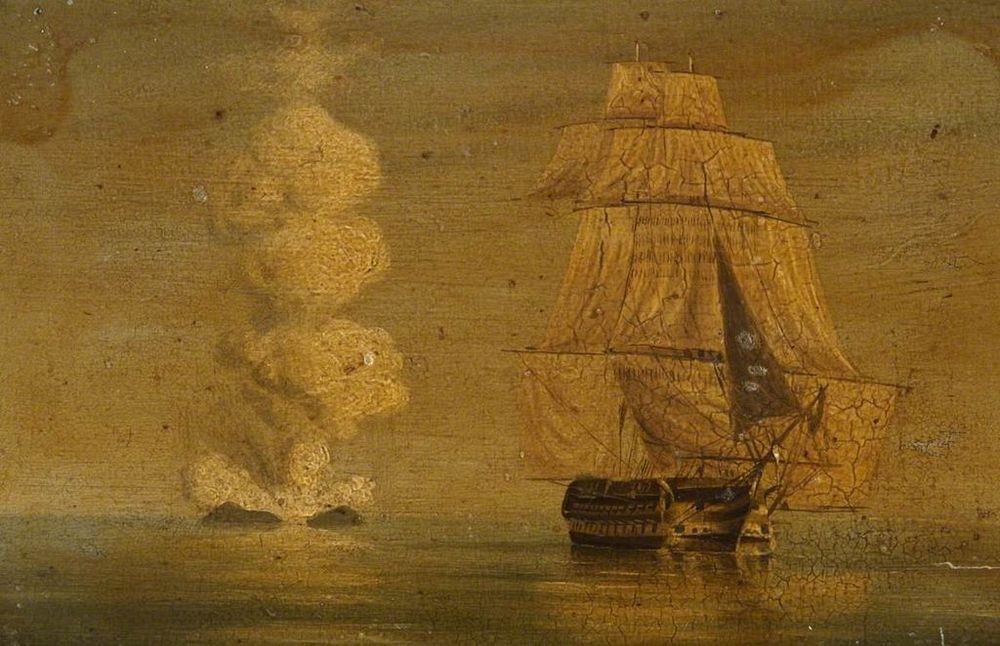
An oil painting depicting the HMS Melville, of the Royal Navy, off the volcanic Ferdinandea Island or Graham Island, 1831. Photo credit: National Maritime Museum
A few days later, a large billowing pillar of smoke was seen rising from the sea. At first, the residents thought that a ship was on fire, but when a passing brig approached the area and saw bubbling water and dead fish floating around, the captain was almost sure it was a sea monster. It was two weeks after the first hint of sulphur, that the emergence of a new island was confirmed.
Throughout that month of July and the next, the island continued to grow, now a prominent landmark visible from the Sicily coast. And it was still active, spewing lava and hot ash from its mouth-like crater. It eventually reached a height of 63 meters and a circumference of 4.8 km. There was a summit on the northeastern side with a plain in the middle, where two small ponds had formed, the larger of which was 20 meters around and 2 meters deep.
The sizeable chunk of rock had appeared at a tactical location close to the major shipping lanes through the Mediterranean, and every nation who had a naval presence in the area realized that whoever claimed the island would be at a position to control all commercial and military sea traffic through the area.
The first to lay claim on the island were the British. A Navy vessel disembarked on the island, planted the British flag and announced it as British territory, naming it Graham Island for the First Lord of the Admiralty. The King of Sicily, Ferdinand II, considering this an infringement on Sicilian waters, dispatched a corvette to claim the new land. He named it Ferdinandea, in honor of himself. The Spanish showed an interest too. The last to arrive on the scene were the French, who compared the eruption to a bottle of champagne being uncorked and named it Ile Julia, after July, the month it first appeared.
For five months the conflict raged as the nations fought in the press and through diplomatic channels. Tourists travelled to see the island and its two small lakes, and the French even announced a plan to build a top-class holiday resort on its beaches. Nobody paid attention that the island was slowly withdrawing into the ocean.
The volcanic material from which the island was formed was so fragmented and soft that it could not withstand the effects of the ocean waves. As soon as the eruption stopped, the sea rapidly eroded it away. By 17 December 1831, the island had disappeared complexly beneath the waves, and the territorial dispute came to a peaceful end.
This was not the first time the island had appeared in this patch of ocean. The island was first reported to have broke surface during the First Punic War, in the 3rd century BC, and since then it has appeared and disappeared four or five times. It made a brief appearance again in 1863, caused by fresh eruption, before sinking back into the sea. Since then, Ferdinandea island or Graham island, has been lying 8 meters below the sea level —within scrapping distance of a ship’s hull. Ships know to avoid it, but to those unfamiliar with the waters, the sunken island may appear as a hidden threat. In 1987, an American pilot on the way to bomb Libya mistook the submerged peak to be a submarine, and dropped depth charges on it.
Photo credit: blog.is
In 2000, renewed seismic activity around Graham Island led volcanologists to speculate that the seamount might once again become an island. To prevent a repeat of the disagreements, this time Italy acted swiftly by sending a team of divers to plant Sicily's flag on the rising seamount in advance of its expected resurfacing. In addition, a marble plaque, bearing the inscription “This piece of land, once Ferdinandea, belonged and shall always belong to the Sicilian people," was lowered into the waves. This plaque was reportedly destroyed within months, possibly by fishing gear but it could also have been vandalism.
Should the island emerge again in near future, it’s unlikely that there’s going to be a major territorial dispute over it, as the island would not have the same strategic importance today that it had in 1831. The island would likely and rightly belong to Italy.
Photo credit: wwimd.xyz
A page from the geological journal of French geologist Constant Prévost, depicting the 1831 eruption of Ferdinandea island.
The marble plaque that was installed on the submarine volcano.
Sources: Wikipedia / The Basement Geographer / Independent / Clan Graham Society / Time.com


Comments
Post a Comment